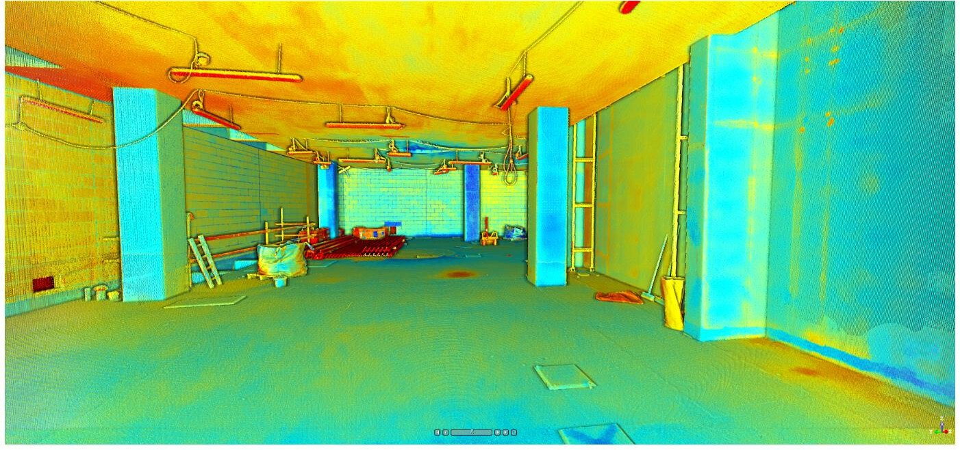
POINT CLOUD

Point Cloud Survey

Point cloud revolutionized survey techniques using lasers to scan in 3D.
 
The results are a highly detailed plan, reducing the need for rework and increasing confidence in the data.


Point Cloud

Point clouds are datasets that represent objects or space — they’re an accurate way of capturing a large number of single spatial measurements into a whole dataset. 


When we generate a point cloud using a 3D laser scanner, each point represents a single laser scan measurement. These scans are then stitched together to create a complete capture of a scene — this process is called registration.


MORE ABOUT PC


CONSTRUCTION APPLICATION

Trimble X7 scanning building site

How it works:

Our skilled team will conduct a full 3D scan survey of the building, Which is then processed using our specialist software to generate a point cloud file. This will be returned to you in your chosen format.

You will be able to access the data with Autodesk Recap/Revit, Teckla or other relevant software to visualise the area and take any required measurements and start your design process.

Your data can also be imported into BIM/CAD software and used as a background reference to create accurate 2D drawings and 3D models.


It is also possible to clean and classify the cloud from unwanted "noise" data such as furniture and trees to only show the desired object/s.


Useful Articles

by Gregorio Bruno 12 Jun, 2023
When it comes to building renovation projects, accuracy and efficiency are essential for successful outcomes. That's where laser scanning survey comes in, providing a fast and accurate method for capturing the existing conditions of a building. At BESurvey, we offer a range of surveying services, including laser scanning, point cloud generation, and scan to BIM, to streamline the renovation process for our clients in London and the UK. The Advantages of Laser Scanning Survey Laser scanning survey is a non-invasive method of capturing data about the existing conditions of a building. It uses a laser scanner to create a point cloud, which is a highly accurate 3D representation of the building's geometry. The point cloud can then be used to create accurate floor plans, sections, elevations, and 3D models of the building. One of the main advantages of laser scanning survey is its speed and accuracy. A laser scanner can capture millions of data points in a matter of minutes, providing a highly detailed and accurate representation of the building. This accuracy is essential for renovation projects, as it ensures that the new design will fit seamlessly into the existing space. Streamlining the Renovation Process Laser scanning survey can streamline the renovation process in a number of ways. Firstly, it provides a highly accurate representation of the existing building, which can be used to create accurate as-built drawings and models. This ensures that the new design will fit seamlessly into the existing space, reducing the risk of errors and rework. Secondly, laser scanning survey can be used to identify any potential issues with the existing building, such as structural issues or MEP conflicts. This allows the design team to address these issues early in the design process, reducing the risk of delays and cost overruns during construction. Finally, laser scanning survey can be used to monitor the progress of the renovation project. By scanning the building at key milestones during the construction process, the design team can ensure that the construction is proceeding according to plan, and make any necessary adjustments along the way. Our Laser Scanning Survey Services At BESurvey, we offer a range of surveying services to streamline building renovation projects. Our laser scanning survey services provide highly accurate 3D representations of the existing building, which can be used to create accurate as-built drawings and models. We also offer point cloud generation and scan to BIM services, which allow us to create 3D models that can be used in the design process. Our team of experienced surveyors and engineers are committed to providing the highest quality service to our clients in London and the UK. We pride ourselves on our attention to detail, accuracy, and efficiency, and work closely with our clients to ensure that their renovation projects are a success. Conclusion Laser scanning survey is a powerful tool for streamlining building renovation projects. Its speed and accuracy, combined with its ability to identify potential issues and monitor progress, make it an essential part of the renovation process. At BESurvey, we offer a range of surveying services to help our clients in London and the UK streamline their renovation projects. Contact us today to learn more about how we can help you.
by Gregorio Bruno 29 May, 2023
Building Information Modeling (BIM) is a process that involves the creation of a digital model of a building, which can be used throughout the entire lifecycle of a construction project. It is a collaborative and data-driven approach that is rapidly gaining popularity in the construction industry. One of the key technologies that play an important role in BIM workflows is laser scanning survey.  Laser Scanning Survey: An Overview Laser scanning survey involves the use of a laser scanner to capture accurate and detailed data about a building's physical features. The scanner emits laser beams that bounce back from the surfaces of the building and are captured by a sensor. The captured data is then processed to create a 3D point cloud, which can be used to generate a highly accurate digital model of the building. The Role of Laser Scanning Survey in BIM Workflows Laser scanning survey plays a critical role in BIM workflows. It enables architects, engineers, and construction professionals to create highly accurate digital models of existing buildings. These models can be used for a variety of purposes, such as renovation and retrofitting projects, as-built documentation, and clash detection. As-Built Documentation Laser scanning survey is particularly useful for creating as-built documentation, which involves capturing accurate data about the physical features of a building that has already been constructed. As-built documentation is essential for renovation and retrofitting projects, as it provides accurate information about the existing conditions of a building. This information can be used to ensure that the proposed changes are feasible and can be implemented without any issues. Clash Detection Clash detection is another important application of laser scanning survey in BIM workflows. Clash detection involves identifying potential clashes or conflicts between different building systems, such as electrical, plumbing, and HVAC systems. By using laser scanning survey to create a highly accurate digital model of the building, construction professionals can identify these clashes before construction begins, which helps to prevent costly delays and rework. Conclusion Laser scanning survey is a key technology that plays an important role in BIM workflows. It enables architects, engineers, and construction professionals to create highly accurate digital models of existing buildings, which can be used for a variety of purposes. Whether it is for as-built documentation, clash detection, or any other application, laser scanning survey helps to enhance the accuracy and efficiency of BIM workflows. At BESurvey, we offer laser scanning survey and a range of other surveying services in London and the UK. Contact us today to learn more about how we can help you with your BIM workflows.
by Gregorio Bruno 22 May, 2023
When it comes to building measurement, accuracy is of the utmost importance. Accurate measurements can help architects, engineers, and builders ensure that their designs and constructions are safe, efficient, and functional. This is where laser scanning survey comes in. What is Laser Scanning Survey? Laser scanning survey is a cutting-edge technology that uses lasers to capture highly accurate measurements of physical spaces. It produces a detailed point cloud that can be used to create 3D models of buildings and structures. This technology is fast, accurate, and non-intrusive, making it an ideal solution for a wide range of applications, including building measurement. How Can Laser Scanning Survey Enhance Accuracy in Building Measurement? Laser scanning survey can enhance accuracy in building measurement in several ways: 1. Reduced Human Error One of the primary advantages of laser scanning survey is that it reduces the potential for human error. Traditional methods of building measurement often rely on manual measurements taken by a human operator. However, manual measurements can be affected by a wide range of factors, including poor lighting, human error, and the presence of obstacles. Laser scanning survey eliminates these issues by automating the measurement process, resulting in measurements that are more accurate and reliable. 2. Detailed Point Cloud Data Laser scanning survey produces a highly detailed point cloud of the building or structure being measured. This point cloud data is incredibly accurate and can be used to create 3D models that are highly precise. By using this data, architects, engineers, and builders can ensure that their designs and constructions are based on accurate measurements. 3. Non-Intrusive Laser scanning survey is a non-intrusive technology that does not require physical contact with the building or structure being measured. This makes it an ideal solution for buildings and structures that are difficult to access or that require careful handling. Additionally, it allows for measurements to be taken without disrupting the normal use of the building or structure. Conclusion Laser scanning survey is a powerful tool that can enhance accuracy in building measurement. By reducing human error, providing detailed point cloud data, and being non-intrusive, laser scanning survey can help architects, engineers, and builders ensure that their designs and constructions are based on accurate measurements. As a survey company based in London, BESurvey provides laser scanning survey services to help clients achieve their construction goals.

Geo-located Point Clouds

By using Control Points, we can correctly geo-reference projects to link registered scans to a project coordinate system 

PC Analysis

 Visualize the whole structure and identify irregularities which cannot be spotted by a site visit or a traditional survey

Mechanical Electrical Plumbing (MEP)

The scanned data provides information on the current situation and insight into possibilities for expansion.

Highly accurate 3D laser scanner

Our team uses a high-speed survey-grade 3D laser scanning system which has up to 2mm accuracy and is effective on dark and reflective surfaces undetectable by most other scanners.  Depending on project requirements captured point density can be adjusted to meet specification.

ARRANGE A SURVEY NOW

Bruno Engineering Ltd

33 Connaught Gardens, Morden, London

07557132697

info@besurvey.co.uk 


© 2022. The content on this website is owned by us and our licensors. Do not copy any content (including images) without our consent. Privacy Policy | Terms and conditions

Share by: